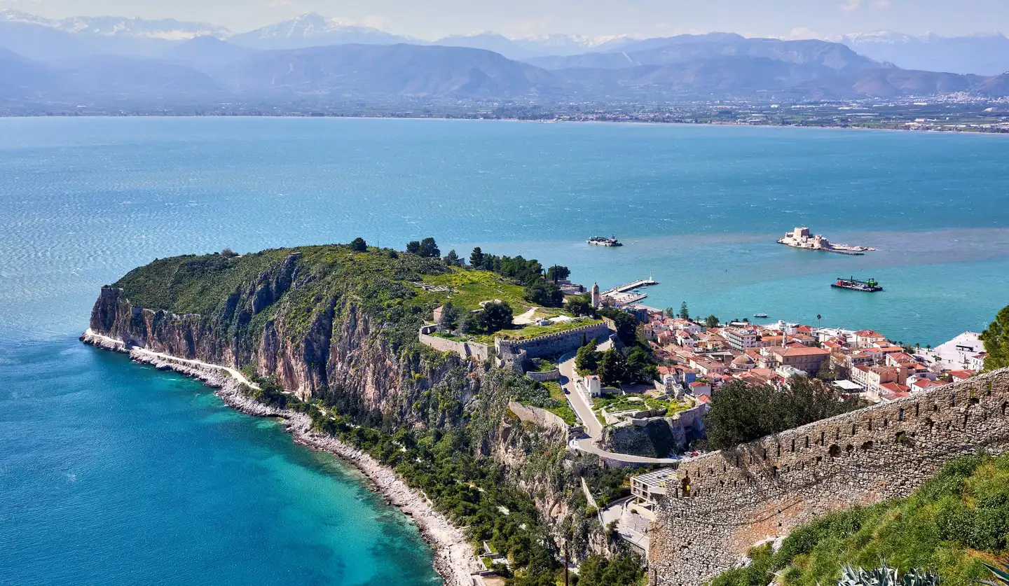
Akronafplia and the old town of Nafplio above the Argolic Gulf, seen from Palamidi

The locationThe Peloponnese, Greece 37°24′N · 23°22′E

Argolida.

Home on the Ermionida coast. Hydra across the water. A whole region to get to know.

Opening plate Nafplio and the Argolic Gulf, from Palamidi Photo: George E. Koronaios IV Nafplio

Explore the region

A place to come back to

Pigadia is on the coast of Thermisia, in Ermionida, with Hydra across the bay. From here, a day can take you to Ermioni for lunch, out to an island, or inland to the theatre at Epidaurus. And at the end of it, back to your own front door.

Around Pigadia

  • Hydra (By sea) ~20 min
  • Ermioni (By road) ~20 min
  • Kilada golf (By road) ~35 min
  • Nafplio (By road) ~1h50
  • Athens (By road) ~3h20
The jetty at Hydra Bay Resort at sunset, with the island coast across the water; a separate property Hydra Bay Resort · separate property
Boats beside the jetty at Hydra Bay Resort, a separate property, in evening light

Hydra Bay Resort · a separate property

A place to set out.

The jetty at the neighbouring resort brings the islands into the day. Each has its own reason to go ashore.

  1. 01Hydra Stone lanes and a harbour to explore on foot.
  2. 02Spetses A walk from Dapia to the old boatyards.
  3. 03Poros The clock tower above town, pine trees by the water.

Residents can use the jetty at Hydra Bay Resort for boarding and mooring, with arrangements made directly with the family. The resort remains a separate property, while the public beach is about 120 metres away on foot.

~20 min
Estimated crossing to Hydra
~120 m
To the public beach on foot

Speak with the family about boat access and mooring. Estimated journey times are shown on the map below.

Chapter IThe islands 01 — 03

An island, for the day.

Hydra, Spetses and Poros each give the day a different shape: a harbour walk, a swim, a long lunch.

Tiled roofs around Hydra harbour, with the mainland coast across the water

~20 min By sea Find on the map

Hydra

37°21′ N · 23°28′ E

Tiled roofs around Hydra harbour, with the mainland coast across the water Photo: Mauricio Muñoz

Stone steps, harbour tables, a day on foot.

The harbour gives way to lanes and steps between stone houses. Hydra is a place to explore on foot: stop for coffee by the boats, then follow the coast towards Kamini. Leave enough of the day unplanned to find a place to sit and watch the water.

Make time for

  1. Coffee by the harbour
  2. The coastal walk towards Kamini
  3. The lanes above the waterfront
  4. The harbour in the evening
A catamaran in front of Hydra harbour, below houses rising up the hillside
Hydra, seen from the water.
Waves at the rocks of Spilia on Hydra, below stone terraces and a Greek flag
The rocks at Spilia, beside Hydra harbour.
A small beach and white houses on a rocky point along the coast of Hydra
A small bay on Hydra.

~40 min By sea Find on the map

Spetses

37°16′ N · 23°09′ E

From Dapia to the old harbour, along the water.

Start at Dapia and take your time along the waterfront to the old harbour. The working boatyards are part of its character: timber boats, repair work and the smell of the sea. A visit to Bouboulina’s house museum adds another chapter to the walk.

Make time for

  1. The walk from Dapia to the old harbour
  2. The traditional boatyards
  3. Bouboulina’s house museum
The Poseidonion hotel on the Spetses waterfront, its pale facade lit by the evening sun
The Poseidonion on the Spetses waterfront.
A white mansion with tiled roofs and palm trees beside the sea on Spetses
A waterfront mansion on Spetses.
Boats in a rocky cove on Spetses, surrounded by wooded slopes
A cove along the coast of Spetses.
The tiled roofs of Spetses, with the sea and mainland coast beyond
Spetses, looking towards the Peloponnese.

~40 min Drive and ferry Find on the map

Poros

37°30′ N · 23°27′ E

A clock tower above the roofs. Pine trees by the sea.

Drive to Galatas and cross by ferry, or arrange a boat journey along the coast. On Poros, climb through the town to the clock tower for the view, then come down to the waterfront. Beyond the town, Love Bay gives you another reason to bring a swimming bag.

Make time for

  1. The view from the clock tower
  2. A walk along the waterfront
  3. A swim at Love Bay
Sailing boats moored below the hillside houses of Poros town
The waterfront of Poros.
A bicycle beside the sea at Galatas, with Poros town and moored sailing boats across the strait
Poros from the waterfront at Galatas.
The bays and waterfront of Poros from above, with boats moored in the water
Poros and the surrounding bays.
A beach on Poros beside clear water, with hills and houses on the opposite shore
A beach on Poros.

Chapter IIErmioni 04

Ermioni, close to home.

About twenty minutes by car. Close enough for lunch by the water to become a familiar habit.

Ermioni at dusk, with boats along the waterfront and the wooded Bisti headland beyond

~20 min By road Find on the map

Ermioni

37°23′ N · 23°15′ E

Ermioni, with Bisti at the end of the peninsula.

The familiar pleasure of a town by the water.

Ermioni stretches along a small peninsula, with fishing boats and places to eat beside the water. Come for lunch, wander through the streets, or walk out among the pines at Bisti. Near enough to visit often, it is a town you can get to know a little at a time.

Make time for

  1. Lunch by the water
  2. The pines at Bisti
  3. An evening walk along the harbour

Chapter IIIGolf at Kilada 05

Room for a round.

The Jack Nicklaus Signature course at Kilada lies among olive groves, about thirty-five minutes by road.

Holes
18
Par
72
Country Club
Kilada
Signature design
Jack Nicklaus
A fairway at Kilada Country Club, with olive trees and a hill beyond
Golf among the olive trees at Kilada.Photo: Kilada Country Club
Illustrated golf hole with olive trees, hills and the sea beyond An illustration inspired by a golf yardage book. It does not show the actual course layout.

~35 min By road Find on the map

Kilada

37°24′ N · 23°08′ E

Golf shaped around the olive groves.

The 18-hole, par-72 Jack Nicklaus Signature design follows the hills and olive groves above Kilada. For those who play, it puts another possibility within reach of home.

Down by the water, the fishing village of Kilada gives the day a different pace. Leave time to see a little of this side of Ermionida too.

Make time for

  1. The course among the olive groves
  2. The fishing harbour of Kilada
  3. Time by the water after your visit

Check current opening, visitor access and tee times directly with the club. Golf access is separate from home ownership.

Chapter IVNafplio 06

Nafplio, at walking pace.

Old streets, a harbour and the fortress above the roofs. About an hour and fifty minutes by road, with time to make a day of it.

~1h50 By road Find on the map

Nafplio

37°34′ N · 22°48′ E

A day for the old streets and the view from above.

Nafplio is a town to walk through slowly, from its old streets and squares to the waterfront facing Bourtzi. Above the red roofs stands Palamidi. Go up for the view, then return to the old town with time for lunch and another wander.

Make time for

  1. The view from Palamidi
  2. Bourtzi from the waterfront
  3. The streets and squares of the old town
Tiled roofs and a domed building in Nafplio old town, with the bay and hills beyond
Over the rooftops of Nafplio.
A paved lane between houses and flowering plants in Nafplio old town
A lane in the old town of Nafplio.
Bougainvillea spilling over balconies above a narrow street in Nafplio
Bougainvillea along the streets of Nafplio.
The cliffs of Akronafplia above blue water, with a coastal path and trees below
The sea below Akronafplia.

Chapter VAncient Argolida 07 — 08

Theatre, sanctuary, citadel.

Epidaurus is about an hour and twenty-five minutes by road; Mycenae, about two hours and fifteen. Two different journeys into the ancient landscape.

The stone seating and circular orchestra of the ancient theatre of Epidaurus, with wooded hills beyond

~1h25 By road Find on the map

Epidaurus & the Asklepieion

37°36′ N · 23°05′ E

The ancient theatre of Epidaurus, from the upper rows.

Take a seat in the ancient theatre.

The stone tiers of Epidaurus open towards the stage and the surrounding hills. Walk up through the theatre, then allow time for the sanctuary beside it. For a performance, check the festival programme and book ahead; a summer evening here can become part of your year.

Make time for

  1. The view across the stone tiers
  2. The sanctuary beside the theatre
  3. A performance, when the programme allows
Rows of stone seats and steps in the ancient theatre of Epidaurus
The stone seats of Epidaurus.
Pink wildflowers among the stones in front of the ancient theatre of Epidaurus
Wildflowers beside the theatre.

At the same site

The Asklepieion

Give the sanctuary its own time.

The theatre belongs to the wider Sanctuary of Asklepios, a UNESCO World Heritage site connected with healing in the ancient world. Among its monuments are the temple, the circular Tholos and the stadium. Together they make a visit here much more than a stop at the theatre.

Make time for

  1. The Tholos
  2. The sanctuary buildings
  3. The ancient stadium
Reconstructed columns among stone ruins and trees at the Sanctuary of Asklepios
At the Sanctuary of Asklepios, Epidaurus.

~2h15 By road Find on the map

Mycenae

37°44′ N · 22°45′ E

Through the Lion Gate, into the citadel.

The scale of Mycenae becomes clear at the Lion Gate and the great stone walls around it. The citadel and the Treasury of Atreus form part of the UNESCO listing shared with Tiryns. Leave time for the museum, where objects from the site bring the ancient city closer.

Make time for

  1. The Lion Gate
  2. The Treasury of Atreus
  3. The site museum
The Lion Gate at Mycenae, set between large stone walls
The Lion Gate at Mycenae, set between large stone wallsPhoto: George E. Koronaios
Stone walls and foundations at Mycenae, with olive trees and the plain beyond
The citadel of Mycenae above the plain.
Olive groves across the hills around Mycenae, with mountains in the distance
The hills around Mycenae.

Chapter VIGetting here

The journey to Pigadia.

Athens is about three hours and twenty minutes away by car. Once here, the roads lead inland and along the coast, while the islands open up another set of journeys by sea.

A winding road through dense woodland, seen from above
By road
By road
A rocky headland bordered by clear blue water, seen from above
By sea
By sea

Near and a little further.

Approximate journey times from the residences by road, or from the neighbouring coast by boat. A way to see what fits into a morning and what deserves a whole day.

  • By road
  • By sea
  • Drive and ferry
  1. 01Hydra ~20 min By sea
  2. 04Ermioni ~20 min By road
  3. 05Kilada golf ~35 min By road
  4. 02Spetses ~40 min By sea
  5. 03Poros ~40 min Drive and ferry
  6. 03Poros ~50 min By sea
  7. 07Epidaurus ~1h25 By road
  8. 06Nafplio ~1h50 By road
  9. Piraeus ~2h By sea
  10. 08Mycenae ~2h15 By road
  11. Athens ~3h20 By road

By road · from the residences

~3h20

to Athens

Calculated to central Athens; allow for traffic and your exact destination.

70 km in a straight line
Directions in Google Maps (opens in a new tab)
  • By road
  • By sea
  • Ferry crossing

Road times are calculated from the residences. Sea times use the resort jetty as a reference point at water-taxi speed, not a scheduled service. Confirm the boat and departure point; allow for traffic, ferry waits and weather. · 37°24′N 23°22′E

How buying works